Products & ServiceS

We offer a wide range of products and services, from maps and site photographs, to the most complex urban planning studies.

Whether evaluating potential development options, working with partners to obtain discretionary approvals, or helping our clients navigate the zoning and entitlement process, we bring our experience and thoughtful approach to everything we do.

 
grey blue.png

Maps and Graphics for BSA Applications

 
Radius Maps.jpg

RADIUS MAPS &

AFFECTED OWNERS LISTS

Our BSA Radius Diagram/Land Use Maps are prepared according to the BSA's current instructions, and we are in contact with the BSA's staff to ensure they meet with approval from both project managers and the Board members alike. What you may not notice is that these maps keep evolving. The clarity of details, the shades of color, and the arrangement of the map have all been enhanced since we last published a portfolio. And we continue to improve even our most basic products all the time.

It only makes sense to have the firm that prepares your Radius Maps also prepare your Affected Owner Lists. After all, the map is how you identify which properties are located within the specific radius. The product itself is self-explanatory. More interesting is what we can do with an Affected Owner List. Check out section 7 for more information on our support services such as Notification Mailings, and Agency Submissions.


zoning+tax+firm.jpg

ZONING, TAX MAPS, AND PRELIMINARY FLOOD MAPS

Preparing the Zoning, Tax and FIRM Maps required with a BSA application is fairly straightforward. You could even do it yourself. Then again, your time is valuable. And since you're already ordering other items, why not have us prepare them for you? The price is very reasonable. The product both polished and professional. Think of it as one less thing you need to worry about.


image collage.png

PHOTOGRAPHS

Nearly every BSA application requires a set of Photographs, and we would be pleased to provide them. Our Photographs are prepared according to the BSA's current instructions, and we are in contact with their project managers to respond to any comments they may have. Each set of Photographs includes a minimum of seven photographs (viewpoints), and up to 10 complete sets, printed in color, for your filing.


Photostreet.jpg

PHOTOGRAPHIC STREETSCAPES

Photographic Streetscapes (also referred to as “streetscape montages”) are a more recent addition to the canon of BSA graphics. And while they are not listed on the checklists available on the BSA's website (as of this writing), they are frequently requested by project managers or the Board, and their preparation is directed for certain types of applications (e.g. pursuant to the Board's September 2015 memorandum concerning new application requirements for Special Permits pursuant to ZR §73-622).

These streetscapes are, in actuality, much more complex than they appear at first glance. In addition to simply stitching together several head-on photographs of the buildings on each block, the Board also requires that the address, lot area, floor area, building height, and FAR of each property appear beneath it. And, if any of the properties shown on the streetscape are the subject of a Board approval, said approval must be identified by calendar number, and if any of the identified characteristics of the building come from the Resolution, that must be noted as well.


Lot Coverage 2.png

COMPARISON STUDIES

There are countless contexts in which the relative characteristics of your proposal serve as the basis of an effective argument; the building is not the tallest on the block; or, the proposed lot coverage is typical of the neighborhood. That's what Comparison Studies—an intentionally broad term—are all about. Just about any set of building characteristics can be plotted to maps, diagrams, or even photographs. And, as the name would suggest, they can be comparative in nature, identifying or highlighting conditions that meet a certain value or threshold (e.g. buildings that are taller than what is proposed, or lot coverage that was approved by the Board in prior applications).


Yard Depth.png

YARD DEPTH DIAGRAMS

Architect's plans show how deep the yards on your site are; but what about the depth of yards in the surrounding area? Short of performing a survey of the entire neighborhood (surely at a cost in the tens of thousands of dollars) our Yard Depth Diagrams are the best alternative. And, they can be augmented by illustrating the proposed building's footprint, the required depth of yards (per the applicable zoning), or can highlight complying or noncomplying conditions.

 
grey purple.png

MAPS AND GRAPHICS FOR DCP APPLICATIONS


Area+%2B+Land+Use.jpg

AREA MAPS & LAND USE MAPS

Land Use Maps are the less-detailed counterpart to Area Maps. (Though Area Maps also show land use, they are not the same thing.) They are typically required in the context of less significant land use approvals, such as Certifications and Authorizations (whereas Special Permits and Rezonings get Area Maps). As of this writing, the DCP website still suggests that you can use a screenshot of the ZoLa website for your Land Use Map. But the Department's standards go on to request that the maps include all sorts of details that are not shown in ZoLa, and would thus need to be added. Or you can have us prepare the map and not have to worry about any of that.

Area Maps are an all-purpose land use map that is required with most applications that are bound for review by the City Planning Commission. (However, don't confuse them with “Land Use Maps.”) They show all manner of things that are relevant to land use review: land uses (obviously), building footprints, zoning districts, building heights, transit lines, street widths, traffic directions, block numbers, and more. And, when prepared for a Zoning Map Amendment or City Map Amendment application, they also illustrate the proposed change.

new+PAS.jpg

PRE-APPLICATION STATEMENT MAPS

Pre-Application Statement (or “PAS”) Maps are the maps required with the submission of a Pre-Application Statement to the Department of City Planning (see PAS Form v2.5, Section 7a). At a minimum, they include a tax map, zoning map, and basic land use map; but may require additional maps, or the illustration of the proposed action, depending on the application type. (Note also that Photographs are also now required with Pre-Application Statements.)

DCP%2BZoning%2BMap%2B2.jpg

ZONING CHANGE MAPS

A zoning change map is a before-and-after version of the zoning map that is a part of a Zoning Map Amendment application. What's interesting is that you are required to use the official zoning map as your base, regardless of whether it makes for a particularly clear map. Thus the purpose of this map is not to effectively communicate what is proposed, but to literally show the reviewer exactly what the zoning map will look like if the application is approved. (Our guess is that the Zoning Change Map is used to aid the Department in preparing their zoning sketch map, which is then the basis of ultimately amending the zoning sectional map.)

DCPPhoto.jpg

PHOTOGRAPHS

Nearly every DCP/CPC application requires a set of Photographs—if only because they are now a required attachment to every Pre-Application Statement (see PAS Form v2.5, Section 7a). Our Photographs are prepared according to the Department's standards, and we are continually refining our templates and process to ensure that they respond to the ever-changing demands of the agency. The good news is that you can recycle the Photographs, using the set from your Pre-Application submission with your formal land use application. (The bad news is that more recently the Department has been asking for updated photographs when they issue comments on land use applications.)

DCPZONING.png

ZONING MAPS

This map is self explanatory. It is simply the relevant zoning sectional map, with your Site or Project Area identified. It becomes only slightly more difficult to prepare when the 600-foot area around the subject Site extends onto more than one zoning sectional map, in which case multiple maps with segments of the radius must be prepared.

DCP Tax Map 2.png

TAX MAPS

Similar to Zoning Maps, Tax Maps are fairly straightforward. But, they can also be extremely complicated. First, your tax map must delineate between the Project Area and Development Site (unless the two are coextensive). Second, if your project area includes several tax blocks, a separate map for each showing a portion of the project area boundary, must be created. Finally, note that depending on the application type, the amount of details that need to be shown on the tax maps varies. For example, a Certification requires a tax map that simply identifies the Development Site, whereas a Zoning Map Amendment application requires a tax map identifying the Development Site, Project Area, Zoning Districts, Commercial Overlay Districts, and Special Districts.

MIH+Map.jpg

MIH MAPS

With the advent of MIH/ZQA (in March 2016) came the introduction of the MIH zoning text amendment map, or "MIH Map" for short. This is the map that will appear in Appendix F of the Zoning Resolution that identifies the area in which participation in the Mandatory Inclusionary Housing Program is applicable as the result of the subject application; this is almost surely any area being rezoned to increase residential density to an R6–R10 district. The MIH Map identifies not only the newly created MIH Area, but also any neighboring IH and MIH areas, as well as the MIH "options" (mixes of unit affordability) that will be available.

Neighborhood Character 1.png

NEIGHBORHOOD CHARACTER DIAGRAMS

Neighborhood Character Diagrams are extremely detailed streetscape elevation drawings that are required with certain types of applications that, and you may have guessed, potentially impact neighborhood character. Examples include Special Permits affecting landmarks or buildings in historic districts, applications for curb cuts where they are not permitted by right, or permitting large-scale developments that do not comply with the underlying bulk regulations.

Ordinarily, streetscape elevations are prepared by the project's architect. However, there are several reasons why we implore you to have us prepare your next Neighborhood Character Diagram: First, TRD wants them done a very specific way, with which we have extensive experience. Second, they almost certainly require extensive site visits and measurements that are not cost effective for architects to perform. And most importantly, TRD has taken to asking for extremely extensive areas to be included in the Neighborhood Character Diagrams. Typically 600 feet from the site, in either direction, on both sides of the street. For that reason our office can prepare the diagrams for a fraction of what an architect would necessarily charge.

zoning comp and confcomp.png

ZONING COMPARISON TABLES & CONFORMANCE COMPLIANCE TABLES

A Zoning Comparison Table is a basic set of before and after zoning regulations that is submitted with a Zoning Map Amendment (rezoning) application. The reason we suggest that you have us prepare it (even though you or your architect could do so) is that DCP wants the tables prepared in a very specific way that we are accustomed to. Also, because we prepare so many of them, we can do so in a cost effective manner.

Similar to the Zoning Comparison Table, the Conformance-Compliance Table is a before-and-after table that is required with Zoning Map Amendment applications affecting 10 or more properties. As with so many things, the reason you should consider having us prepare this item is that it must be done in a specific way, using a specific template, that we are accustomed to.

Visual Corridor.png

VISUAL CORRIDOR DIAGRAMS

A Visual Corridor Diagram is required with certain DCP/CPC applications affecting waterfront properties. But don't go looking for any additional information on their website. As of this writing there are neither samples nor standards in the "applicant portal." Thankfully, you don't need to worry about that. Simply request the Visual Corridor Diagram with your next project, and we'll take it from there. Our staff prepares the diagrams on a regular basis, and is in touch with TRD as to exactly how they would like them prepared.

Zoning Text Map.png

ZONING TEXT MAPS

A Zoning Text Map is a map that appears within the text of the Zoning Resolution, as opposed to being one of the Zoning Maps that appears after the text and appendices. One example is the MIH Maps (as previously discussed) that appear in Appendix F, and illustrate where the Mandatory Inclusionary Housing program is applicable. In fact, maps actually appear throughout the text of the Zoning Resolution (mainly in the special district text). And if you are changing any of these maps, such change is technically a "text amendment" (yes, this can be confusing), and will require a Zoning Text Map illustrating the proposed change.

Zoning Lot Site Plan.png

ZONING LOT SITE PLANS

Certain types of applications that involve the development rights or applicability of zoning across several properties, or even several tax blocks, require a Zoning Lot Site Plan. These plans illustrate the several properties and buildings at issue in the application in a more detailed fashion than any of the other maps that are included with the application; at the same time, they are not architectural plans. They typically include details such as: block and lot numbers, property dimensions, building footprints, building dimensions, easements, widths of streets and sidewalk, and relevant distances between points.

 
grey green.png

MAPS AND GRAPHICS FOR ENVIRONMENTAL REVIEW


CEQR MAPS

By our count, there are no less than 40 different maps and graphics that routinely appear in EAS's and EIS's—and we prepare every one of them. They concern all types of subject matter, from the location of parks and open spaces, to the size and shape of shadows to be cast from proposed and projected developments. They vary in complexity, from basic land use maps, to the three-dimensional models of so-called “Urban Design Diagrams.”

The graphics used in environmental review application are so numerous, in fact, that we can't show you all of them. What appears in the following pages is just a sample. The point is, we prepare them all.

The examples above are the most basic of the lot, and are needed as early as the submission of a Reasonable Worst Case Development Scenario memo. They are, in clockwise order from top left: Site Location Map, Land Use Map, Aerial Map, and Tax Map.

Environmental+Review+Flood+Maps.jpg

Flood Maps

Environmental+Review+Historic+District.jpg

Historic District Maps

Environmental+Review+Open+Space.jpg

Open Space Maps

Environmental+Review+Community+Facility.jpg

Community Facility Maps

Shadow+4.jpg

CEQR SHADOW ANALYSES

Urban Cartographics offers shadow analyses prepared in a variety of styles: from adhering to specific agency standards, to custom presentations that speak to a specific finding. Most of our shadow analyses are one of two types: those prepared according to the CEQR Technical Manual, and more advanced studies that are prepared for a custom purpose (see following section).

Pursuant to the City's CEQR Technical Manual, a Shadow Analysis must follow a specific process for identifying, or ruling out, the possibility of shadow impacts on "sunlight-sensitive resources" (i.e. parks, open spaces, certain landmarks). In short, the analysis progresses through a series of "tiers;" if an impact cannot be ruled out in one tier, we proceed to the next. For projects that will result in shadow impacts that means, at a minimum, Tiers 1–3, and a set of Tier 3 Incremental Impact drawings; and may require additional three-dimensional diagrams to further illustrate the exact nature of the impact.

Shadow Advanced 3.png

ADVANCED SHADOW ANALYSES

Among the myriad products Urban Cartographics prepares, advanced shadow analyses is among the most complex. They are custom products in that they are prepared to address a particular question; or a particular shadow impact, as opposed to running through CEQR's series of tiers.

urbandesign.jpg

URBAN DESIGN DIAGRAMS

The Urban Design Diagram is an illustration intended to capture the visual and spatial impact of new development on the streetscape. To that end, it typically features a series of three-dimensional building models, showing both proposed and projected developments, set in the context of a streetview-style photograph. Typically, both "with-action" and "no-action" development scenarios are drawn, dimensioned, and added into the streetview photograph. In addition to modeling the proposed development, Urban Design Diagrams must also include the likely form of "projected" development sites.

Land+Use+Detailed.jpg

DETAILED LAND USE SURVEYS

We're very lucky to have the City's PLUTO land use data available to us with just a few clicks. But what to do when you know the data is wrong, or simply not detailed enough? For example, identifying every building in the area that has ground floor retail frontage. Or, confirming whether the properties shown in purple on a land use map are actually active manufacturing facilities. The answer is to have us perform a detailed land use survey. It's exactly what it sounds like. We go out to the field, and we record both the type of use (i.e. store, restaurant, medical office) and the particular tenant (i.e. Duane Reade, Starbucks) in your project area. The results can be provided in a table, or plotted onto a map. They can also be cross-checked against certificates of occupancy, classified by Use Group, and identified by the closest corollary in the Zoning Resolution's "Index of Uses."

air+quality.jpg

DEP AIR QUALITY PERMIT RESEARCH

A variant of the Detailed Land Use Survey (above) is the Air Quality Permit Search. Here, a survey of the 400-foot radius around a project site is undertaken to confirm the location and activity of manufacturing and industrial properties, and to identify certain noxious commercial and automotive uses (such as dry cleaners, or auto body shops). Once a list of all properties that may have a DEP Air Quality Permit on file is created, a formal request to review such files is made to DEP. Thereafter, once permits associated with the several properties have been identified and pulled from archives, we venture out to the DEP offices in Elmhurst and scan all of the relevant permits to pdf and return them to you.

 
grey pink.png

PROJECT-SPECIFIC STUDIES


The maps and graphics that appear in the preceding sections have one in thing in common: they are all required as part of different types of land use applications. That’s what you have to submit. Now, let’s talk about what you’ll want to submit. Which is custom-made, project-specific maps, graphics and studies. This is what will set your work apart.

Unlike required graphics, that are prepared according to a set of agency requirements (that we often don’t even particularly agree with), project-specific studies are an opportunity for us to collaborate with you; and to bring your argument to life in visual form. Suppose you are claiming that the height of a proposed building makes sense when the size and shape of the taller buildings in the area is considered; that your lot is uniquely shaped; or that a commercial overlay ought to continue for another block. Those aren’t points best made in writing. Instead, how about a map indicating the height of the surrounding buildings, and identifying those that are talker than what’s proposed; a diagram indicating the internal angles of irregular lots in the area, that explains that your corner has the most acute angle; or a survey of existing land uses that confirms that extending that overlay would actually marked reduce the block’s degree of nonconformance. Yes, all of these issues will still receive due treatment in your writing, but just think about how much more effective the argument becomes when coupled with the imagery. It’s that relationship that is the intense focus of our Project-Specific Studies.

Urban+Planning+Study.jpg

PRELIMINARY MEETING PRESENTATIONS

You only get one chance to make a first impression; why not put your best foot forward? Our Preliminary Meeting Presentation is the perfect accompaniment to your next preliminary meeting request. We prepare several maps of the project site and surrounding area with a set of photographs, and other relevant information to create a professional presentation. What community district is the project in? How far from the next community district? Where are the subway lines in this neighborhood; how about bus routes? What's across the street? Every one of these questions have been asked in a preliminary meeting, and not having the answers at hand can bring the discussion to a screeching halt. You could: print the tax map, print the zoning map, print out pages from OASIS and ZOLA, print out Google streetviews, and then bring them all to your meeting. Instead, why not have us prepare a polished presentation that includes all of that and more? In short, make sure the attachments are every bit as professional as your writing.

Preliminary Meeting 10.png
Preliminary Meeting 9.png
Preliminary Meeting 7.png
Preliminary Meeting 8.png
 

STUDIES FOR BSA APPLICATIONS

Variance Applications 3.png

UNIQUENESS STUDIES

Uniqueness is the first finding of the NYC variance (ZR 72-21(a)). If you can't establish uniqueness, the analysis never gets past it. If you took on the case, you surely believe the subject property suffers from a unique hardship. Now to the question of how you'll prove it.

Our Uniqueness Studies run the gamut from simple maps (e.g. showing every lot less than 25 feet wide in the zoning district), to complex reports in which we consider all manner of conditions inherent in the zoning lot (from steep slopes, to the geometry of the site's shape). Not only do we prepare the graphics used to illustrate uniqueness, we can also prepare a complete report that explains the analysis and firmly establishes the uniqueness finding.

Neighborhood Study.png

NEIGHBORHOOD CHARACTER STUDIES

The "c" finding of New York City's variance is that the proposed development does not threaten to alter the character of the district in which it is located, nor threaten to impair the use of adjacent properties. Increasingly, the Board of Standards and Appeals has required applicants to submit something more than assertions of the finding; namely particular analyses aimed at comparing the proposed conditions (and zoning waivers and modifications necessary to achieve them) to the existing character of the district. To that end, our office prepares all manner of studies to establish that proposed developments do not alter the character of the district.

Finding Specific.png

FINDING SPECIFIC STUDIES FOR BSA APPLICATIONS

Certain findings all but require you to submit a map or diagram. How else to show the percentage of the congregants to a house of worship that live within three-quarters of a mile of the site, or that the site of a proposed school is within 400 feet of a district where the school would be permitted as-of-right? Our office prepares all manner of such studies, each with the express purpose of aiding you in making your findings.


STUDIES FOR DCP APPLICATIONS

Finding Specific 8.png

FINDING-SPECIFIC STUDIES FOR DCP APPLICATIONS

Our finding-specific studies need not be limited to the specific findings of the Zoning Resolution. To be sure, we work with our clients to produce maps and studies illustrating all manner of conditions. The common thread of all of these is that they aid you in analyzing sites in a way that is virtually impossible—or at least impossible to illustrate—otherwise.

Retail+use.jpg

RETAIL USE SURVEYS

There are numerous contexts in which an in-person survey of retail use can be critical to your application. For example, in the past few years the Department of City Planning has begun to require that Area Maps for certain types of applications in certain areas—namely applications to permit retail use in SoHo—identify the location of ground floor retail use. Or, as in the example above, a survey of retail use was performed simply to establish that ground floor retail was consistent with neighborhood character.

Land+Use+Detailed+2.jpg

DETAILED LAND USE SURVEYS

A detailed land use survey, identifying not just the general land use but the specific type, can address the nuance of your argument. In this case, the question presented was whether there was adequate separation between a proposed school and the surrounding non-residential uses, per ZR §73-19(c). How else to answer that question than to know exactly what the surrounding uses are, in particular?

Urban Design Features.png

URBAN DESIGN FEATURES MAPS

Urban Design Features maps are a recent addition to the canon of maps required by the NYC Department of City Planning, in direct response to the creation of the several Special Permits available in Industrial Business Incentive Areas (ZR §74-96 et. seq.). Such maps identify not only land use, but street trees, benches, Citibike stations, and other streetlevel ("urban design") features in the 600 feet surrounding a project site. To create such maps, our office performs an inperson survey of the surrounding area to record the location of all of the above referenced features.

Residential%252BGrowth%252B2.jpg

RESIDENTIAL GROWTH PARKING STUDIES

Residential parking growth studies arise in the context of applications to allow off-street parking in the "Manhattan Core" pursuant to ZR §13-40 et. seq. They are a logical way to compare the number of parking spaces eliminated by new development to auto ownership trends in the district, while at the same time an extremely complex level of analysis for what is often just a handful of parking spaces. To explain, the Residential Growth Parking study is supposed to look at how many parking spaces have been lost as new development replaces former parking lots and parking garages, but also how many parking spaces are gained in the form of parking spaces in new developments. The analysis must also consider the number of residential units eliminated as old buildings are demolished, and the new number of new residential units created in new buildings. All of this supports the goal of establishing that by adding more parking spaces than permitted in a particular development, the approval will not have the effect of inducing automobile ownership, and thus automobile use, in the district.

The complexity of the matter is compounded by the fact that the available data, both as it relates to residential unit counts (from DOB filing data) and parking space counts (from DCA data) is generally incorrect (in our last study, more than half of such data was later found to be in error). For that reason, the number of units must be confirmed by reference to CO's, and the location and quantity of parking spaces must be confirmed by an on-the-ground survey.

 
grey red.png

GENERAL URBAN PLANNING STUDIES AND SERVICES


 A large part of what we offer is bridging the divide between land use attorneys and developers (our primary clients), and the urban planners who review their land use applications. In essence, empowering our clients to speak the same language as the planners, who generally prefer maps and graphics to the written word. Nowhere is this more important than in the context of a proposal, such as a rezoning, that is an exercise in urban planning. In such cases it is essential to present the proposal in the style and vernacular of urban planning, so that the agency planners can champion your proposal as if it were their own.

Planning+and+Zoning.jpg

PLANNING AND ZONING STUDIES

To our minds, what is really happening when we prepare planning and zoning studies is two things.

First, you are conveying a depth of care for the subject matter (land use and zoning) comparable to that of your audience. In other words, you are showing a planner that you undertake the same degree of care in crafting a proposal that they do. And, this depth of analysis shows that you understand that you need to make a case, beyond simply asking for something.

At the same time, you are expressing a degree of empathy in that you understand that ultimately a staff member may have to defend your proposal as though it were their own. And what you are doing is showing them that you will provide support if they adopt your proposal.

Historical Use 1.png

HISTORICAL USE RESEARCH

In order to establish the continuity of a nonconforming use, or a nonconforming sign, you will often have to document what has existed on a site for decades. As you likely know, property owners are not the best at maintaining records, let alone photographs and other documentation. That's where we come in. Our staff are well-versed in all of the resources available for researching the history of NYC buildings and properties. We can perform such research at City agencies, on the internet, and at various other places (such as university libraries, and archives). When such research is complete it becomes part of a formal report that you can include with your ZRD1, or other application. The photograph of the building shown here, taken between 1940 and the present, was used to successfully establish the continuity of nonconforming ground floor retail use.

Sightline+1.jpg

SIGHTLINE STUDIES

There are basically two types of Sightline Studies: one documenting from where new construction can be seen, and the other documenting what can be seen from a particular location. The former most often appears in applications before the Landmarks Preservation Commission. In the example at right, the areas from which a proposed rooftop installation atop a landmarked building would be visible were analyzed by photographing the building from a series of vantage points throughout the subject neighborhood.

A more interesting question we are frequently called upon to investigate is what the view from a particular building will be, and what the chances are they will be blocked by future construction. In such cases we typically model the location of the subject unit, and then undertake a systematic review of the surrounding area to determine the properties that are ripe for new development. Next, we estimate the size and shape of such new developments. Finally, we take the results of our analysis and create a series of maps, diagrams, or augmented photographs that explain how views are likely to be affected by future development.

Parking+Study.jpg

PARKING SURVEYS AND STUDIES

There is nothing special about a parking study. It just needs to get done. And then the results need to be documented. It's typical that our work (be it photographs or a land use survey) will take us to the site anyway; so why not have us perform the parking survey while we are there? What's more, since we are presumably already preparing other maps for the application, it makes sense to have us prepare one more: showing the results of the survey. Such surveys typically include not only the number of cars parked, but also the number of on-street spaces believed to exist (in total), the location of off-street parking facilities (and their capacity), and the nature of on-street parking regulations.

Planning+Policy.jpg

PLANNING POLICY RESEARCH

An effective way of advocating for your project is to argue that it is consistent with the City's land use planning and policy. Unfortunately, in New York such plans and policies are not set forth in a single Comprehensive Plan (as in other jurisdictions), but rather are the perpetual synthesis of land use and planning studies, reports, and decisions by the City Planning Commission and the City Council. It follows that determining just what the City's plans and policies are takes a good deal of research. That's where we come in. Our office offers, as a service, to research recent actions, reports, and studies in the area surrounding your project, or which are relevant to your project. The results of that research are presented in a written report, or a series of maps and graphics.

Business+and+Employment.jpg

BUSINESS AND EMPLOYMENT STUDIES

When zoning changes reduce the amount of area that is zoned for commercial or manufacturing use, one concern that is often raised is that the change will result in the loss of jobs or businesses to the City's economy. At the scale of the neighborhood, or even the scale of the block, the best (if not the only) way of quantifying such impacts is to perform a business and employment survey. This product is exactly what is sounds like: We visit the area in question, recording the number and type of businesses in each building, and knocking on doors and speaking to staff to determine how many people are employed at each location (at least so far as respondents are willing to share that information). The results of our survey are compiled in a presentation that include maps, photographs, and the pertinent data.

Character+Destination.jpg

CHARACTER-DESTINATION STUDIES

Beyond land uses, generally, there is often the question of whether or not the neighborhood infrastructure exists to support a proposed development, For example, even if there is generally support for rezoning a portion of a manufacturing district to allow for residential use, do the necessary supporting services (from public schools to convenience stores, to transit options) exist? Our neighborhood destination studies are squarely focused on this question. They typically identify certain classes of use (retail, community facilities, transportation) within an extending radius (i.e. quarter-mile) from a project site.

Drone+Photography+2.jpg

DRONE PHOTOGRAPHY

In the past few years, custom aerial photographs—once only possible by airplane or helicopter at a cost in the thousands of dollars—have been made accessible using drones. To be fair, for most projects drone photographs are overkill. But in certain cases, they are invaluable. For example, large scale developments, larger sites without internal paths, undeveloped sites consumed by woods or vegetation, or in cases where you seek to illustrate the relative height of the surrounding buildings.

Building Architecture Survey 2.png

BUILDING/ARCHITECTURAL SURVEYS

There are a number of dimensions along which neighborhood character can be measured: land use, height, floor area, etc. While all of those are useful, sometimes a more particular approach is necessary; one that considers the actual themes of design that characterize a place. With that in mind, our architectural and building surveys offer a fine-grained approach to establishing neighborhood character (or appropriateness, in the context of Landmarks' work) that focuses on the architectural elements and details that define the character of a place.

Sanborn+1.jpg

SANBORN MAPS

You may be thinking: Anyone can order Sanborn Maps; how is that an Urban Cartographics product? If you simply want the maps, we agree. But why stop there? The maps can be customized in any number of ways: from simply identifying your site, to identifying particular uses, or particular building types in the area surrounding your site over time.

 
grey orange.png

ADVANCED ZONING ANALYSIS


Why prepare a zoning analysis without graphics? Sure, it's done all the time; in the form of zoning opinions, and memorandums. Or in the form of analyses by code consultants and architect who use little (if any) visuals to explain how zoning applies. To our minds, such analyses leave much to be desired since they effectively ignore the old adage that a picture is worth a thousand words.

That you may not personally have the capacity to produce graphics doesn't mean your next zoning analysis shouldn't include them. To be sure, compelling illustrations take zoning analyses to the next level; from good to great. And whether we perform the analysis, or simply illustrate your findings, your next zoning analysis should include them.

Massing Studies.png

MASSING STUDIES

The most basic type of zoning analysis we prepare is a massing model. This is simply a three-dimensional model of the applicable bulk regulations, along with corresponding figures (floor area, FAR, height, etc.).

Development Rights.png

DEVELOPMENT RIGHTS ANALYSES

One context in which zoning analysis proves exceptionally valuable is in the scenario planning that surrounds transfers of development rights. For example, what can be developed on the site alone? What if the site is merged with the adjacent lot, or two lots, or three? What if existing buildings remain, and what if they are cleared to make way for the new development?

COMPLETE ZONING ANALYSIS

Zoning analysis is an essential step in development planning, from the very earliest stages. The most advanced form of zoning analysis we offer begins with little more than potential sites, and asks the fundamental question: what can be done? In the examples shown below, we were tasked with analyzing potential development options for 12 properties owned by a single institution, across three tax blocks. In this case, unlike most, the owner did not arrive at the inquiry with any preconceived notion of what could, or should be developed on the sites. In fact, whether the sites should be developed as 3, 4 or 5 assemblages was undecided.

Next, working with our partner Red Flux Architecture (who are highly recommended) we developed site plans, schematic drawings, and three-dimensional models for six potential developments; five mixed use (residential–commercial) developments, depending on how the several sites were assembled; and an alternative commercial development for one of the sites (that was in a different zoning district than the others). All of the same were presented, alongside our zoning calculations, in a detailed report.

 
grey yellow.png

SUPPORTING SERVICES FOR LAND USE PRACTICE


Once upon a time it was true, without exception, that running a thriving land use practice required a Manhattan office and a support staff. It's still true that the support is necessary, but it's no longer true that you have to be local or hire staff to get it. Like so many things in our modern and connected world, much of the land use process—including some of the most tedious parts—can be outsourced. Whether it's making agency submissions, performing notification mailings, or even attending executive sessions, nearly the entire land use approval process can be outsourced. The only question, then, is how much of your time you want to take back.

mailing.jpg

NOTIFICATION MAILINGS

Every time you receive a Notice of Hearing that must be mailed to the surrounding property owners, the problem is the same: suddenly several hours of additional work get dropped in someone's lap, and it needs to be done right away—it's at once unexpected, and urgent. Rather than ask someone to stay late, or delay their other tasks, you can simply have our office perform the mailing. After all, do you really need to have a paralegal (or worse yet, an associate) spend any time stuffing envelopes? Simply forward the notification to our office. We will complete the mailing according to agency standards, and will submit the proof of mailing directly to the agency for you.

Notice+on+Pole+-+36+Central+Park+South.jpg

NOTIFICATION POSTINGS

Certain community districts, or other community groups, ask that meeting notices are either distributed to surrounding businesses and residences, or posted on lampposts in the surrounding area and at the subject Site. (Additionally, effective June 2019, the BSA requires posting hearing notices in the lobby of buildings where legalizing a Physical Culture Establishment is proposed.). Who's going to do that? Do you send a paralegal? Do you ask the client if they can help? You don't need to ask those questions. Simply email the meeting notice and posting instructions, and our staff will perform the posting as soon as possible. When it's complete, you will receive photographs of the posted notices, a map indicating the location where the notices were posted, or an affidavit attesting to the distribution or posting of the notices (when applicable).

IMG_0885.jpg

AGENCY SUBMISSIONS

The most valuable support service our firm offers—at least in our opinion—is performing agency submissions. Here's what happens: When you submit your submission email to either “submit@bsa...” or “centralintake@planning...” simply cc us; or, if you prefer, forward the email along with additional instructions as needed. We will immediately begin preparing the submission, per agency standards, and make an appointment to submit at the agency's offices. Your submission will be performed (i.e. clocking, stamping, and voiding) by an experienced staff member. The referral mailing (i.e. copies to councilperson, community board etc.) will be completely pursuant to agency requirements (a copy can also be mailed to you.) In short, you'll be able to perform your submission without having to print, copy, collate or staple a single piece of paper. Indeed the submission will be done, on your end, as soon as you hit send on the email. Which means you can submit without coming to Manhattan. You can submit without having a support staff. You can submit from home. You can submit from whatever beach you are vacationing on. Just think about it.

Support+Services.jpg

PRESENTATION BOARDS

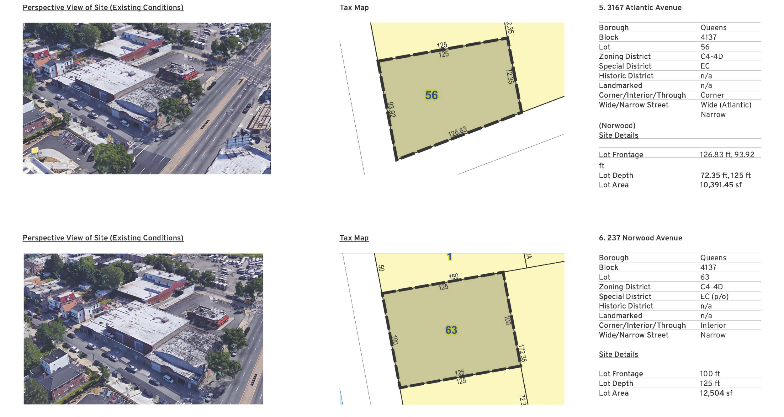
Presentation boards have long been used to aid in presenting projects in public meetings. You may be wondering, though, why you should still go through the trouble of having them made up in an era of powerpoints and projectors. Well first, it's no longer "trouble"—we've taken the hassle out of ordering presentation boards (as explained below). But the real answer is, we're not there yet. Many public hearing rooms, community board offices, and other venues do not have a projector or screen, and specifically direct speakers not to bring electronic presentations. Those that do often offer an antiquated laptop computer, or poor lighting. And is there anything worse than getting up to present your big and important project, only to have a technical problem that you have to try and troubleshoot while an impatient (if not hostile) audience fumes at the delay?

Presentation boards "work" every time, but until now, they've been a pain. You have to send your files to a print shop, which may or may not understand how you want them printed, and could take days. Then, when they are done you need to arrange to have the boards shipped from the printer back to your office, at an additional cost.

When you order presentation boards from Urban Cartographics, though, the entire process is simplified. First, we understand the material you want printed on boards; maybe we even produced some of it. Second, our presentation boards include, in the price, delivery to any location in Manhattan, or to the outer boroughs at a modest fee. Last but not least, we can even affix quarter-sized magnets to your presentation boards so that if you are presenting in front of a magnetic white board (like the one at 22 Reade Street), your boards snap up effortlessly.

05CustomMeetPres1.jpg

CUSTOM MEETING PRESENTATIONS

Some people prepare a custom presentation for their public meetings and hearings, some just insert relevant parts of the application into a PowerPoint, others have no presentation at all. To be fair, that says more about the complexity (or controversy) of the matter than it does about the practitioner. That being said, there are times when you need something special to support your presentation, and we would be pleased to prepare a custom presentation. Again, this is not just a few of the graphics from your application (you can pull those together yourself ). This is when you need to use visuals to translate the complexity of the application into something that you can use to explain the proposal with to the public, elected officials, or an administrative body.

APPLICATION DRAFTING

Sometimes drafting an application is the ultimate expression of your skill as a land use practitioner. Other times, it is rote process; finding the best template, inserting accurate details, and proofing. When it's the latter, you don't need to do it yourself, and it may even be a waste of your time. If that's the case, we are more than happy to help. We've drafted all manner of land use applications, from PCE special permits to complex rezonings; from preliminary meeting requests, to discussions of findings to modify topographic features. Even if you can't imagine relinquishing this most essential of roles, imagine having your first draft—the one where you have to look up the block, the lot, the community district, the council district—prepared for you.

And in case you don’t want your colleagues to know you have a ghost writer, don’t worry, your secret is safe with us. Just think, until now you probably didn’t realize that documents drafted by Urban Cartographics have been used to secure hundreds of land use approvals over the past ten years.

AGENCY RESEARCH

Traveling to a City Agency, waiting in line to submit a research request, then waiting for someone to pull your file, and then sorting through old documents looking for a particular detail is nothing if not time consuming. Can you spare 2-3 hours of your time, or your associate's, looking for something as simple as an old set of approved plans, or a 1940 tax photo, or a 1970's rooftop sign permit application? Whether it's reviewing a file from the BSA archives, following up on a FOIL request at the Department of City planning, or going through project folders and microfiche at the Department of Buildings, why not send us instead? It's almost certainly faster (our staff is at the City agencies downtown nearly every day), and more cost effective, than going down yourself. Besides, you should reclaim the time to work on something more important.

RESEARCH AND MEMOS

Where do you turn when you need someone to perform research related to NYC land use, and you or your associates are busy? Call us. We have extensive experience researching all types of questions. For example: How many times has the BSA granted a variance in an M1-5 or M1-6 district in Manhattan to permit residential use, and when they have, what FAR's have been approved? Or: Have there been any rezonings in this neighborhood in the past 20 years that increased FAR or expanded the list of permitted uses, and if so, what was the rationale (or political motive) at play? There's no reason to waste the time of an associate or paralegal when you can simply have the research and memo prepared for you.