

PROJECT-SPECIFIC STUDIES
The maps and graphics that appear in the preceding sections have one in thing in common: they are all required as part of different types of land use applications. That’s what you have to submit. Now, let’s talk about what you’ll want to submit. Which is custom-made, project-specific maps, graphics and studies. This is what will set your work apart.
Unlike required graphics, that are prepared according to a set of agency requirements (that we often don’t even particularly agree with), project-specific studies are an opportunity for us to collaborate with you; and to bring your argument to life in visual form. Suppose you are claiming that the height of a proposed building makes sense when the size and shape of the taller buildings in the area is considered; that your lot is uniquely shaped; or that a commercial overlay ought to continue for another block. Those aren’t points best made in writing. Instead, how about a map indicating the height of the surrounding buildings, and identifying those that are talker than what’s proposed; a diagram indicating the internal angles of irregular lots in the area, that explains that your corner has the most acute angle; or a survey of existing land uses that confirms that extending that overlay would actually marked reduce the block’s degree of nonconformance. Yes, all of these issues will still receive due treatment in your writing, but just think about how much more effective the argument becomes when coupled with the imagery. It’s that relationship that is the intense focus of our Project-Specific Studies.

PRELIMINARY MEETING PRESENTATIONS
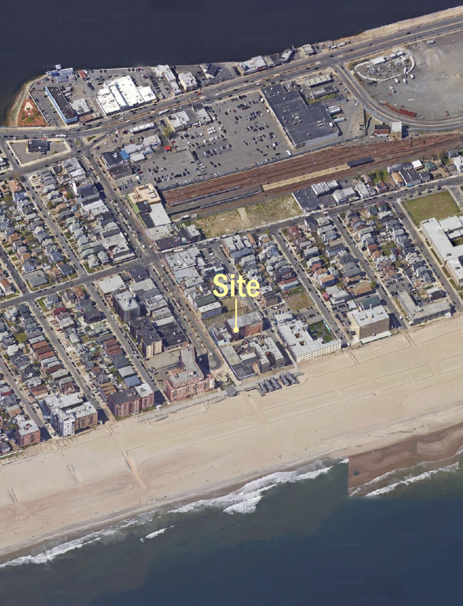
You only get one chance to make a first impression; why not put your best foot forward? Our Preliminary Meeting Presentation is the perfect accompaniment to your next preliminary meeting request. We prepare several maps of the project site and surrounding area with a set of photographs, and other relevant information to create a professional presentation. What community district is the project in? How far from the next community district? Where are the subway lines in this neighborhood; how about bus routes? What's across the street? Every one of these questions have been asked in a preliminary meeting, and not having the answers at hand can bring the discussion to a screeching halt. You could: print the tax map, print the zoning map, print out pages from OASIS and ZOLA, print out Google streetviews, and then bring them all to your meeting. Instead, why not have us prepare a polished presentation that includes all of that and more? In short, make sure the attachments are every bit as professional as your writing.


STUDIES FOR BSA APPLICATIONS

UNIQUENESS STUDIES
Uniqueness is the first finding of the NYC variance (ZR 72-21(a)). If you can't establish uniqueness, the analysis never gets past it. If you took on the case, you surely believe the subject property suffers from a unique hardship. Now to the question of how you'll prove it.
Our Uniqueness Studies run the gamut from simple maps (e.g. showing every lot less than 25 feet wide in the zoning district), to complex reports in which we consider all manner of conditions inherent in the zoning lot (from steep slopes, to the geometry of the site's shape). Not only do we prepare the graphics used to illustrate uniqueness, we can also prepare a complete report that explains the analysis and firmly establishes the uniqueness finding.

NEIGHBORHOOD CHARACTER STUDIES
The "c" finding of New York City's variance is that the proposed development does not threaten to alter the character of the district in which it is located, nor threaten to impair the use of adjacent properties. Increasingly, the Board of Standards and Appeals has required applicants to submit something more than assertions of the finding; namely particular analyses aimed at comparing the proposed conditions (and zoning waivers and modifications necessary to achieve them) to the existing character of the district. To that end, our office prepares all manner of studies to establish that proposed developments do not alter the character of the district.

FINDING SPECIFIC STUDIES FOR BSA APPLICATIONS
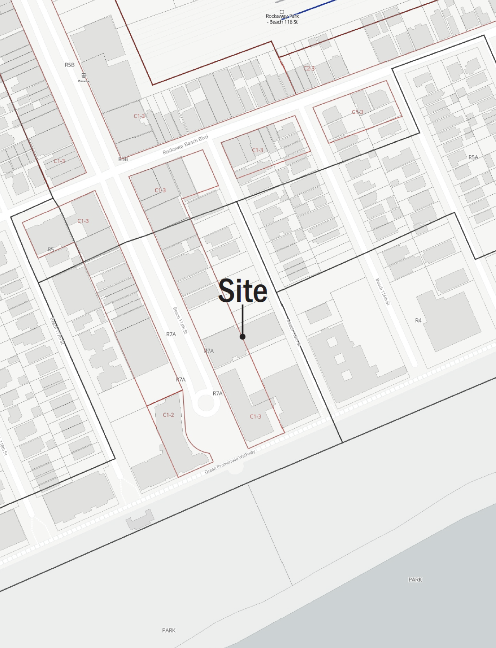
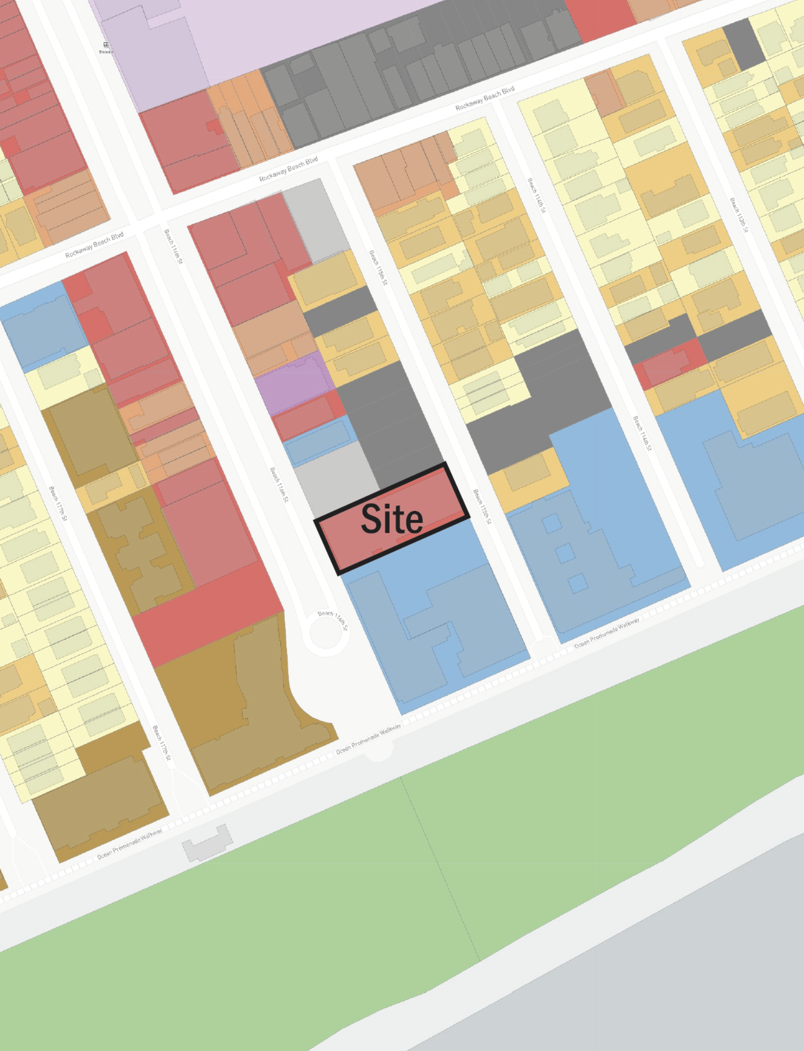
Certain findings all but require you to submit a map or diagram. How else to show the percentage of the congregants to a house of worship that live within three-quarters of a mile of the site, or that the site of a proposed school is within 400 feet of a district where the school would be permitted as-of-right? Our office prepares all manner of such studies, each with the express purpose of aiding you in making your findings.
STUDIES FOR DCP APPLICATIONS

FINDING-SPECIFIC STUDIES FOR DCP APPLICATIONS
Our finding-specific studies need not be limited to the specific findings of the Zoning Resolution. To be sure, we work with our clients to produce maps and studies illustrating all manner of conditions. The common thread of all of these is that they aid you in analyzing sites in a way that is virtually impossible—or at least impossible to illustrate—otherwise.

RETAIL USE SURVEYS
There are numerous contexts in which an in-person survey of retail use can be critical to your application. For example, in the past few years the Department of City Planning has begun to require that Area Maps for certain types of applications in certain areas—namely applications to permit retail use in SoHo—identify the location of ground floor retail use. Or, as in the example above, a survey of retail use was performed simply to establish that ground floor retail was consistent with neighborhood character.

DETAILED LAND USE SURVEYS
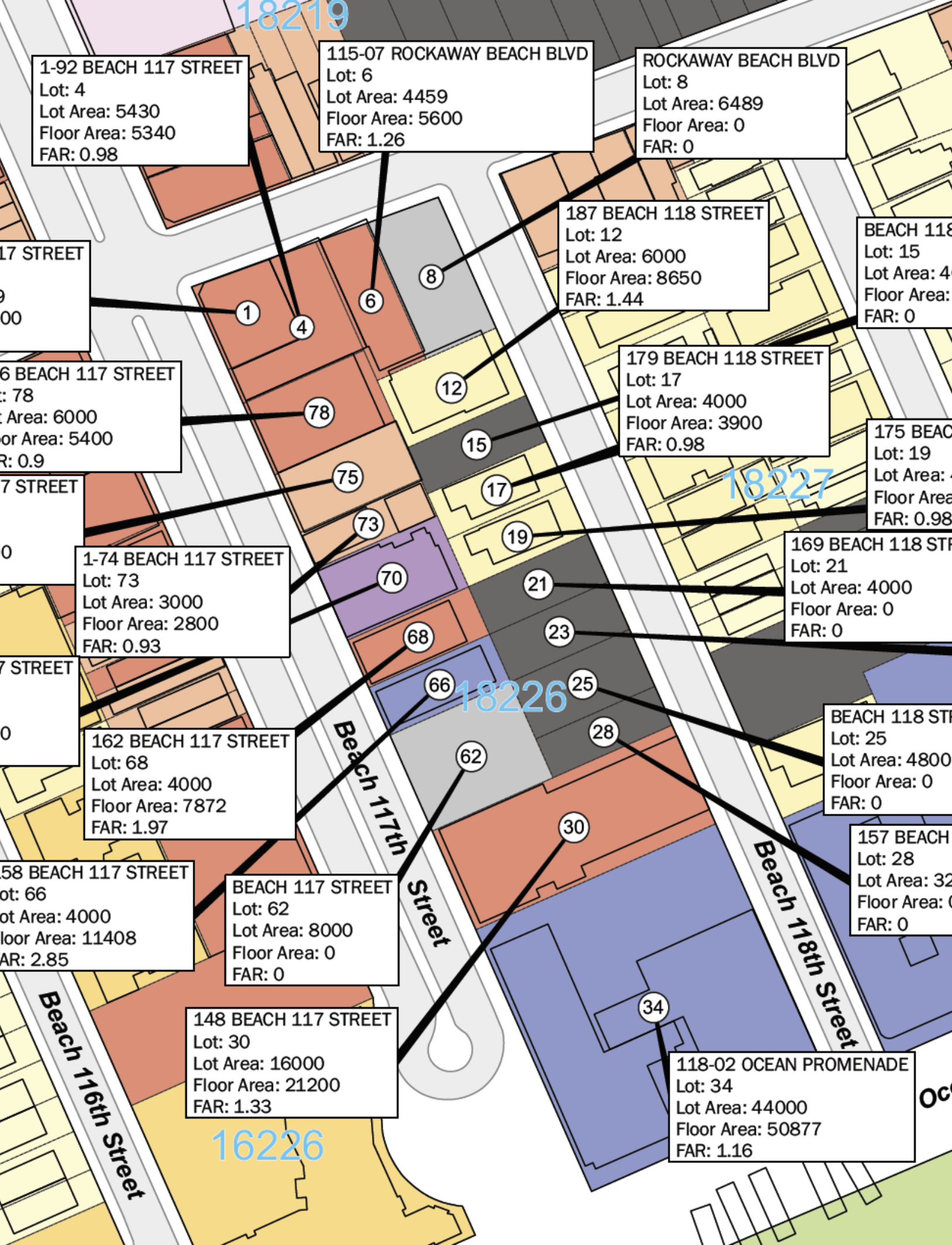
A detailed land use survey, identifying not just the general land use but the specific type, can address the nuance of your argument. In this case, the question presented was whether there was adequate separation between a proposed school and the surrounding non-residential uses, per ZR §73-19(c). How else to answer that question than to know exactly what the surrounding uses are, in particular?

URBAN DESIGN FEATURES MAPS
Urban Design Features maps are a recent addition to the canon of maps required by the NYC Department of City Planning, in direct response to the creation of the several Special Permits available in Industrial Business Incentive Areas (ZR §74-96 et. seq.). Such maps identify not only land use, but street trees, benches, Citibike stations, and other streetlevel ("urban design") features in the 600 feet surrounding a project site. To create such maps, our office performs an inperson survey of the surrounding area to record the location of all of the above referenced features.

RESIDENTIAL GROWTH PARKING STUDIES
Residential parking growth studies arise in the context of applications to allow off-street parking in the "Manhattan Core" pursuant to ZR §13-40 et. seq. They are a logical way to compare the number of parking spaces eliminated by new development to auto ownership trends in the district, while at the same time an extremely complex level of analysis for what is often just a handful of parking spaces. To explain, the Residential Growth Parking study is supposed to look at how many parking spaces have been lost as new development replaces former parking lots and parking garages, but also how many parking spaces are gained in the form of parking spaces in new developments. The analysis must also consider the number of residential units eliminated as old buildings are demolished, and the new number of new residential units created in new buildings. All of this supports the goal of establishing that by adding more parking spaces than permitted in a particular development, the approval will not have the effect of inducing automobile ownership, and thus automobile use, in the district.
The complexity of the matter is compounded by the fact that the available data, both as it relates to residential unit counts (from DOB filing data) and parking space counts (from DCA data) is generally incorrect (in our last study, more than half of such data was later found to be in error). For that reason, the number of units must be confirmed by reference to CO's, and the location and quantity of parking spaces must be confirmed by an on-the-ground survey.